Most of the New Jersey Turnpike was built from 1949 to 1951, with the entire road open by January 1952. However, a “western spur” in Hudson and Bergen counties opened in 1971, to divert George Washington Bridge traffic away from Lincoln Tunnel traffic and also to serve the proposed Meadowlands Sports Complex, which opened in 1976. Also in 1971, the one-mile “missing link” of I-95 opened between US 46 in Ridgefield Park and I-80 in Teaneck; the connector between I-80 and the George Washington Bridge had opened in 1966.
The portion of I-95 south of US 46 has been part of the New Jersey Turnpike since its opening. The four-mile stretch between US 46 and US 9W was taken over by the Turnpike Authority in 1992, with the Authority “paying” the state for the privilege in order to help Gov. James Florio balance the state budget. The Port Authority of New York and New Jersey controls the George Washington Bridge section, from US 9W in Fort Lee to the Harlem River Drive in New York.
Only the 8.10-mile portion of the freeway in Bergen County is included here. Dual mile markers are included in this log, with the NJDOT markers originating at the Delaware River (the Pennsylvania Turnpike connector) and the NJTP markers originating at the southern end of Turnpike Authority control in Carneys Point, Salem Co.
Turnpike interchange numbers 1-18 are serial, starting from the southern end of the Turnpike in Deepwater. (The Turnpike has since added exits 7A in Robbinsville, 8A in Cranbury, 13A in Elizabeth, and 15X in Secaucus. The western spur has exits marked 15W, 16W, and 18W.) I-95 exit numbers 68-73 are mileage-based, but they correspond to the original planned alignment through Somerset County that was never built.
| Mile | ||||
| NJDOT | NJTP | Street Name | Feature | |
| 69.86 | 115.11 | Entering Ridgefield Boro | ||
| 69.86 | 115.11 | New Jersey Turnpike | Bellmans Creek {bridge} | |
 Northbound, crossing Bellmans Creek into Bergen County. | ||||
| 70.98 | 116.23 | New Jersey Turnpike | U-turn, official use only | |
| 71.00 | 116.25 | New Jersey Turnpike | Susquehanna Railroad {overpass} | |
| 71.09 | 116.34 | New Jersey Turnpike | West Shore Railroad {overpass} | |
| 71.18 | 116.43 | New Jersey Turnpike | U-turn, official use only | |
| 71.32 | 116.57 | New Jersey Turnpike | NJ Turnpike western spur |
|
| 71.41 | 116.66 | New Jersey Turnpike | NJ Turnpike western spur |
|
| 71.42 | 116.67 | Roadway splits into local and express alignments | ||
| 71.43 | 116.68 | New Jersey Turnpike | Unnamed stream {bridge} | |
| 71.81 | 117.06 | New Jersey Turnpike | Overpeck Creek {bridge} | |
| 71.81 | 117.06 | Entering Ridgefield Park Village | ||
| 71.93 | 117.18 | New Jersey Turnpike | Bergen Tpk |
|
| 72.03 | 117.28 | New Jersey Turnpike | [Maintenance yard entrance, official use only] | |
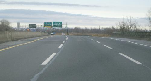
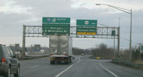 Old-fashioned rotating signs at the northbound exit for Route 46. | ||||
| 72.31 | 117.56 | New Jersey Turnpike | ||
| 72.48 | 117.73 | Emerson Rd {underpass} | ||
| 73.47 | 118.72 | Entering Teaneck Twp | ||
| 73.59 | 118.84 | Bergen-Passaic Expwy |
||
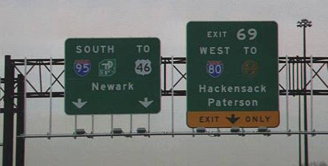 Southbound signage for I-80 exit, redone to NJ Turnpike standards. | ||||
| 73.97 | 119.22 | Bergen-Passaic Expwy | Teaneck Creek {culvert} | |
| 74.10 | 119.35 | Bergen-Passaic Expwy | DeGraw Ave Extension, |
|
| 74.76 | 120.01 | Bergen-Passaic Expwy | Overpeck Creek {bridge} | |
| 74.76 | 120.01 | Entering Leonia Boro | ||
| 75.05 | 120.30 | Bergen-Passaic Expwy | Flat Rock Brook {culvert} | |
| 75.10 | 120.35 | Entering [Englewood City] (Leonia Boro) | ||
| 75.12 | 120.37 | Bergen-Passaic Expwy | Railroad {overpass} | |
| 75.26 | 120.51 | Bergen-Passaic Expwy | Grand Ave |
|
| 75.47 | 120.72 | Entering Englewood City | ||
| 75.58 | 120.83 | Bergen-Passaic Expwy | Broad Ave, Interchange 71 NB off/SB on {overpass} | |
| 75.71 | 120.96 | Entering Leonia Boro | ||
| 75.89 | 121.14 | Bergen-Passaic Expwy | Edgewood Rd {underpass} | |
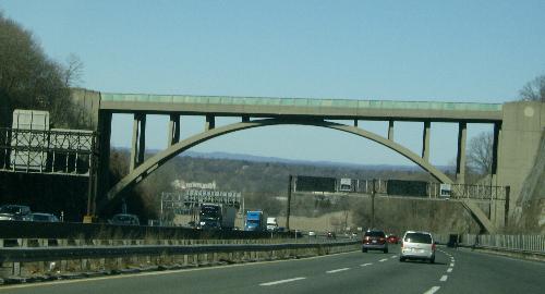 The famous Edgewood Road underpass, as seen looking southbound on I-95. The Great Seal of the State of New Jersey once adorned the empty circles at each end.  Looking southbound (westward) from atop the Edgewood Road bridge. 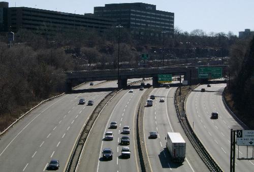 Looking northbound (eastward) from atop the Edgewood Road bridge. |
||||
| 75.99 | 121.24 | Entering Fort Lee Boro | ||
| 76.20 | 121.45 | Bergen-Passaic Expwy | ||
| 76.53 | 121.78 | Bergen-Passaic Expwy | ||
| 76.62 | 121.87 | Bergen-Passaic Expwy | ||
| 76.66 | 121.91 | Bergen-Passaic Expwy | ||
| 76.78 | 122.03 | Bergen-Passaic Expwy | Fletcher Ave |
|
| 76.78 | End New Jersey Turnpike Authority jurisdiction; begin Port Authority of NY & NJ jurisdiction | |||
| 76.78 | Next 1.18 miles co-signed with |
|||
| 76.89 | George Washington Br | Linwood Ave |
||
| 77.02 | George Washington Br | Center Ave [ |
||
| 77.11 | George Washington Br | [Toll plaza, lower level] | ||
| 77.18 | George Washington Br | Lemoine Ave |
||
| 77.23 | George Washington Br | Hudson St {upper level merge} | ||
| 77.28 | George Washington Br | [Toll plaza, upper level] | ||
| 77.40 | George Washington Br | Hudson Terr |
||
| 77.53 | George Washington Br | Palisades Interstate Pkwy |
||
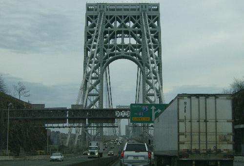 At last, the great gray bridge. | ||||
| 77.59 | George Washington Br | Henry Hudson Dr {bridge} | ||
| 77.96 | George Washington Br | Hudson River {bridge} | ||
| 77.96 | ||||
| 0.00 | Entering New York City, New York Co. | |||
Only the 6.32-mile segment of the road in Bergen County is included here. Dual mile markers are included in this log, with the NJDOT markers originating at the split between eastern and western spurs in Newark and the NJTP markers originating at the southern end of Turnpike Authority control in Carneys Point, Salem Co.
| Mile | |||
| NJDOT | NJTP | Street Name | Feature |
| 4.70 | 110.41W | Entering Lyndhurst Twp | |
| 4.70 | 110.41W | New Jersey Turnpike | Sawmill Creek {bridge} |
| 5.04 | 110.75W | New Jersey Turnpike | Kingsland Ditch {culvert} |
| 5.31 | 111.02W | New Jersey Turnpike | Kingsland Creek {bridge} |
| 5.34 | 111.05W | New Jersey Turnpike | Lackawanna Railroad {bridge} |
| 5.48 | 111.19W | New Jersey Turnpike | Unnamed stream {bridge} |
| 5.76 | 111.47W | New Jersey Turnpike | Berrys Creek {bridge} |
| 5.76 | 111.47W | Entering Rutherford Boro | |
| 6.21 | 111.92W | New Jersey Turnpike | U-turn, official vehicles only {overpass} |
| 6.24 | 111.95W | New Jersey Turnpike | Erie Railroad {overpass} |
| 6.24 | 111.95W | Entering East Rutherford Boro | |
| 6.59 | 112.30W | New Jersey Turnpike | Unnamed stream {culvert} |
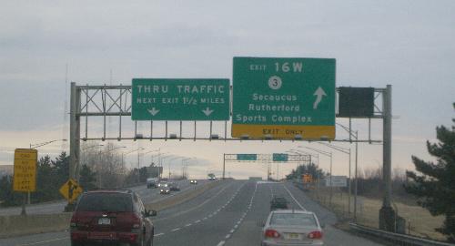 The reason for the western spur: the exit for the Meadowlands Sports Complex. | |||
| 6.91 | 112.62W | New Jersey Turnpike | Berrys Creek Canal {bridge} |
| 7.02 | 112.73W | New Jersey Turnpike | Interchange 16W ramp {bridge} |
| 7.12 | 112.83W | New Jersey Turnpike | |
| 7.24 | 112.95W | New Jersey Turnpike | |
| 7.27 | 112.98W | New Jersey Turnpike | U-turn, official use only {overpass} |
| 7.39 | 113.10W | New Jersey Turnpike | Unnamed stream {culvert} |
| 7.72 | 113.43W | New Jersey Turnpike | Unnamed stream {culvert} |
| 7.92 | 113.63W | Entering Carlstadt Boro | |
| 7.97 | 113.68W | New Jersey Turnpike | Paterson Plank Rd {underpass} |
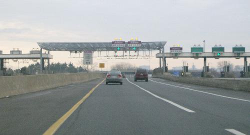 The Interchange 18W toll plaza, now configured for Express E-ZPass. | |||
| 8.08 | 113.79W | New Jersey Turnpike | Interchange 18W toll plaza |
| 8.33 | 114.04W | New Jersey Turnpike | Sports Complex access road {underpass} |
| 8.35 | 114.06W | New Jersey Turnpike | Unnamed stream {culvert} |
| 8.73 | 114.44W | New Jersey Turnpike | Unnamed stream {culvert} |
| 9.10 | 114.81W | New Jersey Turnpike | Unnamed stream {culvert} |
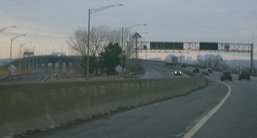 The western spur is about to cross the Hackensack River. | |||
| 9.34 | 115.05W | New Jersey Turnpike | U-turn, official use only {bridge} |
| 9.63 | 115.34W | New Jersey Turnpike | Hackensack River {bridge} |
| 9.63 | 115.34W | Entering Ridgefield Boro | |
| 9.80 | 115.51W | New Jersey Turnpike | U-turn, official use only {bridge} |
| 9.90 | 115.61W | New Jersey Turnpike | Service area access road {bridge} |
| 10.07 | 115.78W | New Jersey Turnpike | Vince Lombardi service area {ramps} |
| 10.30 | 116.01W | New Jersey Turnpike | Susquehanna Railroad {overpass} |
| 10.40 | 116.11W | New Jersey Turnpike | West Shore Railroad {overpass} |
| 10.60 | 116.31W | New Jersey Turnpike | Ramp to eastern spur {overpass} |
| 10.69 | 116.40W | New Jersey Turnpike | Unnamed stream {pipe} |
| 10.78 | 116.49W | New Jersey Turnpike | Ramp to eastern spur {overpass} |
| 11.03 | 116.74W | New Jersey Turnpike | NJ Turnpike |