Highways of Bergen County, New Jersey
In December 1959, the Planning Board of the County of Bergen produced a study of the county highways, with the intent of establishing a new system of primary, secondary, and minor county roads. The primary routes would establish major north-south and east-west routes across the county, with the secondary routes supplementing these and the “minor” routes consisting of all the existing county roads that were not included as primary or secondary routes. The Planning Board presented its report to the Board of Chosen Freeholders in March 1960.
For the primary routes, the Planning Board recommended the use of mostly existing county roads, but they also included existing municipal roads and new rights-of-way. The new rights-of-way (ROW) were mostly in undeveloped or underdeveloped sections of the county, although some of them are hard to imagine today. While the Planning Board cited a threefold increase in average county road traffic between 1938 and 1958, it may not have foreseen the continued development that has made Bergen County the state’s largest by population, estimated in 2008 to exceed 900,000. Most of the Planning Board’s recommendations for new county roads (either over municipal roads or new ROWs) were not implemented.
In the early 1960s, the state was also revising its 500-series system of secondary highways, most of which are maintained by the various counties. (There are a few exceptions. Some 500 routes run on municipal roads, while some overlay state routes.) Some of the finished 500-series roads utilize the routes envisioned by the Planning Board as county primary routes. Most of the rest of the recommended primary routes were eventually established and signed, with numbers below 25 which follow the rule of cardinal direction. (The lowest existing county route number was 25, as the route system was established prior to 1927, when no state highway route had a number above 20.)
Of course, this choice of low numbers for the primary routes means that some of them have numbers that coincide with state highways (such as 3, 4, 5, and 17).
Signs on many of the primary routes bear the primary route number rather than the official number which is carried by the State of New Jersey in its straight-line diagrams (and, apparently, by the county for internal inventory purposes). Some of them, however, are signed with both the inventory number and the primary route number, particularly where a primary route encompasses parts of several previously existing county roads.
Here is a description of the primary routes, both as they were originally envisioned by the Planning Board and as they are signed today:
North-South Routes
NS-1
Proposed: From Oakland to Mahwah along Ramapo Valley Road, CR 91.
Implemented: Never. The road is signed as US 202; CR 91 signs also exist.
NS-2
 |
Proposed: From Franklin Lakes to Mahwah, using High Mountain Road, CR 89, out of North Haledon, then Ewing Avenue, up to Franklin Avenue; then via a new ROW to the corner of Pulis Avenue and Campgaw Road (may have incorporated Green Ridge Road, a local street), and then up Campgaw Road to Darlington Avenue, Primary Route EW-1.
Implemented: There is a lonely CR 3 sign at the corner of High Mountain Road and Ewing Avenue, so this portion did become part of the route. The new right-of-way in Franklin Lakes was never acquired; CR 3 follows Franklin Avenue and Pulis Avenue to get to Campgaw Road.
|
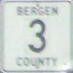
NS-3
 |
Proposed: From North Arlington to Ridgewood along River Road, Riverside Avenue, Jackson Avenue, Carlton Avenue, Locust Avenue, Midland Avenue, River Drive, River Road, Wagaraw Road, and Lincoln Avenue, CR 77.
Implemented: CR 507 was shifted to this route between the Belleville Turnpike and the Maple Avenue bridge in the early 1960s. North of the Maple Avenue bridge, CR 77 does carry CR 5 signs, but the designation is deprecated.
|
NS-4
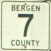 |
Proposed: From Fair Lawn to Upper Saddle River along Maple Avenue, Sheridan Avenue, and West Saddle River Road.
Implemented: CR 507 was shifted to this route between the Maple Avenue bridge and Franklin Turnpike in the early 1960s. North of Franklin Turnpike, the former CR 77 is signed as CR 7.
|
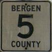
NS-5
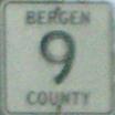 |
Proposed: From Fair Lawn to Ridgewood, along Saddle River Road, north of NJ 4, and Prospect Street, ending at NS-4.
Implemented: Entire route is signed as CR 9; however, CR 9 and CR 79 are jointly posted south of where Ackerman Avenue splits off from Prospect Street. The CR 79 designation is now limited to south of NJ 4/208.
|
 |
Proposed: To be implemented as secondary route in original 1959 plan.
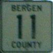
Implemented: CR 11 is signed along Schuyler Avenue, Page Avenue, and Orient Way, the former CR 130. This may have occurred after CR 507 was shifted to the Passaic River route along CR 69 (see NS-3, above).
|
NS-6
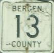 |
Proposed: From Maywood to Westwood, along Maywood, Forest, and 4th Avenues, CR 59, then over section of Forest Avenue in Westwood under municipal control, then Lafayette Avenue, CR 110, ending at EW-2.
Implemented: CR 13 is signed along entire route of the former CR 59, Maywood Avenue, Forest Avenue, 4th Avenue, and 3rd Avenue. The municipal section of Forest Avenue in Westwood was acquired by the county and is designated as CR 13, but not signed.
|
NS-7
Proposed: From Carlstadt to Montvale over Moonachie Road, a new ROW in Hackensack, River Street, Main Street, and Kinderkamack Road.
Implemented: This would have been CR 15. Most of this eventually became CR 503, except that CR 503 follows Hackensack Avenue rather than Main/Johnson/Kinderkamack into River Edge. CR 503 also got routed over existing East Moonachie Road and River Road in Hackensack, rather than the proposed new ROW, which would have been impractical because of the proposed Bergen-Passaic Expressway, which is mentioned in the report but not shown on the planning map.
NS-8
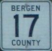 |
Proposed: From Ridgewood to Old Tappan, using Bergen Turnpike and Ridgefield Avenue, now CR 50; a new ROW adjacent to the West Shore tracks; Railroad Avenue and River Road; local streets through Oradell (probably Elm and 1st); Lake Shore Drive in Haworth; a new ROW to the corner of Old Hook and Schraalenburgh roads; then Schraalenburgh Road, CR 39, Lafayette Street, CR 39A, a new ROW up to Old Tappan Road, DeWolf Avenue, and Orangeburgh Road, CR 106A.
Implemented: None of the new ROWs was implemented. As posted, CR 17 uses Bergen Turnpike, CR 50; then Teaneck Road, CR 39; then Mount Vernon Avenue, Railroad Avenue, and River Road, CR 17; then Madison Avenue, CR 6; then Washington Avenue and Schraalenburgh Road, CR 39; then Lafayette Avenue/Road, Blanch Avenue, Cripplebush Road, and Washington Avenue, CR 109; then Old Tappan Road, CR 114; then Orangeburgh Road, CR 106A. The county logs show only the former CR 41 portion from Ridgefield Park to New Milford as part of CR 17; the rest of the primary route is deprecated.
|
NS-9
Proposed: From Teaneck to Northvale, along a new ROW from NJ 4, into Englewood along Lafayette Place, CR 37, then up Knickerbocker Road and Livingston Street, CR 37.
Implemented: This would have become CR 19. However, the new ROW was never acquired in Teaneck and Englewood; everything north of Palisade Avenue was CR 503 and eventually became CR 505.
NS-10
Proposed: From Englewood to Rockleigh, using Grand Avenue, Engle Street, County Road, Anderson Avenue all the way up to Pierson Avenue, then a new ROW into Rockleigh, connecting to Piermont Road. Anderson Avenue is under municipal control north of Closter Dock Road.
Implemented: Most of this became CR 501. The county-controlled section of Anderson Avenue, the cormer CR S-33, became CR 21, although no CR 21 markers exist today. The new section in Closter/Alpine and Rockleigh was never acquired.
East-West Routes
EW-1
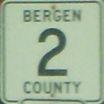 |
Proposed: From Mahwah to River Vale, starting at NS-1, using Darlington Avenue, ; a new ROW bridging the Erie tracks in Ramsey; then Lake Street, Crescent Avenue, Ramsey Road (today's Lake Street in Upper Saddle River), Grand Avenue and Blue Hill Road.
Implemented: CR 2 was signed along this entire route, except that the new ROW in Ramsey was never acquired. Instead, CR 2 was signed along Central Avenue, CR 85, and Main Street, which was acquired as an extension of CR 87.
|
EW-2
 |
Proposed: From Oakland to Alpine, starting at NS-1, using Franklin Avenue, Hollywood Avenue, a new ROW to bypass Wearimus Road in Ho-Ho-Kus, then Washington Avenue, Old Hook Road, High Street, and Closter Dock Road.
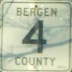
Implemented: Franklin Avenue was signed as CR 4 up from US 202 to Ewing Avenue. The rest of the route is CR 502, except that the new ROW was not acquired.
|
EW-3
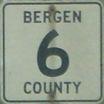 |
Proposed: From Wyckoff to Demarest, starting with a new ROW from the proposed interchange of Cedar Hill Avenue and NJ 208 (which was still under construction) to a bend in Wyckoff Avenue; then Wyckoff Avenue and Lake Street, CR 87; then Godwin Avenue, Franklin Avenue, Maple Avenue, Ridgewood Avenue, and Oradell Avenue up to the Boulevard in New Milford, all CR 80; then a new ROW along the Oradell-Haworth line, New Street, Massachusetts Avenue, Lenox Avenue (the last three all municipal roads), and County Road (a portion of CR 501), ending at NS-10.
Implemented: The new ROW from NJ 208 was never acquired. Unsure if CR 6 was ever posted west of Goffle Road; however, CR 6 is currently logged by the county as following the bulk of former CR 93 to Wyckoff Avenue. It then uses Wyckoff Avenue, Lake Street, and all of the former CR 80 from Lake Street to Kinderkamack Road. New Milford Avenue in Oradell is still municipally maintained, but CR 6 then is signed along Madison Avenue and Hillside Avenue, the former CR 74, which was part of the old Route 200.
|
EW-4
Proposed: From Ridgewood to New Milford, starting from NS-5 and using Grove Street (municipal), Midland Avenue (municipal and then CR 70), and River Edge Road, CR 70, ending at NS-8.
Implemented: This was apparently never signed with a low number although it would logically have been CR 8. The municipal sections were never acquired.
EW-5
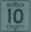 |
Proposed: From Hackensack to Englewood Cliffs, starting from NS-7 just north of Sears and using Hackensack Avenue, New Bridge Road, a new ROW between the Northern Railroad tracks and Teaneck Road, then Liberty Street (CR 68 again) and Palisade Avenue (municipal from Knickerbocker Road to Engle Street and then CR 66), ending at Hudson Terrace.
Implemented: CR 10 is signed along New Bridge Road and Liberty Street, formerly CR 49. The section south of Main Street in River Edge is part of CR 503, while the section east of Knickerbocker Road is part of the old alignment of CR 503 and is now part of CR 505, including the portion that is maintained by the City of Englewood.
|
EW-6
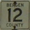 |
Proposed: From East Paterson to Fort Lee, using Market Street, Essex Street, Court Street, a new ROW jumping from Fort Lee Road to Main Street Extension in Bogota, DeGraw Avenue, a new ROW in Teaneck east of Teaneck Road, then Fort Lee Road, ending at US 46.
Implemented: CR 12 is signed along just about all of the former CR 56, which follows the route above and continues eastward to Hudson Terrace.
The new ROW in Bogota was never acquired, so eastbound CR 12 follows Fort Lee Road, CR 56, and River Road, CR 17, before joining Main Street. Westbound CR 12 traffic continues across the Midtown Bridge and then uses East Salem Street (a section of CR 56, River Street, CR 503, East Kansas Street, the former CR C-4, and Hudson Street, once part of CR 124, to get back to Essex Street.
The new ROW in Teaneck was acquired in conjunction with the construction of the Bergen-Passaic Expressway; it is called DeGraw Avenue Extension and is included as part of CR 12.
|
EW-7
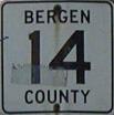 |
Proposed: From Wallington to Carlstadt/East Rutherford, using Paterson Avenue, CR 120, Hoboken Road, CR S-55, and Paterson Plank Road, ending at NS-7. This was the posted path of NJ 3 in the 1930s. EW-7 and NS-7 share a terminus, the northern edge of NJ 20.
Implemented: CR 14 is signed along Paterson Avenue for its entire length, rather than Hoboken Road. Paterson Plank Road from NJ 17 to NJ 20 was taken over by the state in the early 1970s as an extension of NJ 20 to accommodate the Sports Complex; it is now NJ 120.
|
“North-West” Routes
NW-1
Proposed: From Ridgewood to Ho-Ho-Kus, starting from NJ 17 and using Franklin Turnpike, CR 112, crossing NS-4 and ending at NS-2.
Implemented: Never. The stretch is still signed as CR 62.
NW-2
Proposed: Entirely within Fairview, the existing Fairview Avenue, then CR 48, now CR 16, and Bergenwood Road, CR 23. (Yes, a Numbered Primary Route had a spur.)
Implemented: The county now considers this to be CR 16, the next East-West number in sequence. The NJDOT signal overhead at Broad Avenue still shows this as CR 48, however.
Return to Bergen Highways home page
Copyright © 2016 Charles O’Reilly. All rights reserved.
This page is not associated with the Bergen Co. Highway Department or the New Jersey Department of Transportation.
E-mail the webmaster