Skyline Drive is a beautiful (and hazardous in rain or snow) mountain crossing to Ringwood and the Wanaque Reservoir. The plans for NJ 208 envisioned a road going in roughly this direction and then heading north, perhaps paralleling Sloatsburg Road and Sterling Lake Road, but the highway would have been difficult to build over Ramapo Mountain and through what are now considered prime conservation areas. Much of its path in New York is part of Sterling Forest State Park, itself part of a greater Highlands land conservation effort. To partially alleviate traffic concerns, Bergen and Passaic counties combined to build the two-lane Skyline Drive in the late 1950s.
The West Oakland Avenue and Skyline Drive section was added to CR 4 at a later date than the original designation. West Oakland Avenue continues southward into Pompton Lakes, where it becomes Colfax Avenue. There is no East Oakland Avenue; West Oakland Avenue runs through a part of town called West Oakland.
| Mile | Street Name | Feature (West to East) |
| Note: West of here is Passaic |
||
| 0.00 | ||
| 0.38 | Entering Wanaque Boro, Passaic Co | |
| Skyline Dr | Next 0.27 mile is Passaic |
|
| 0.65 | Entering Oakland Boro, Bergen Co | |
| 2.41 | Skyline Dr | |
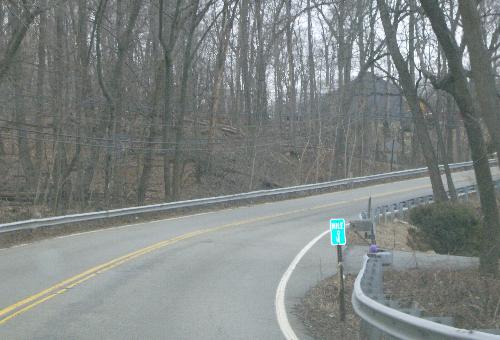 Heading up the Skyline Drive hill. The mile marker, probably placed by Bergen County, indicates 0.4 mile from the start of Skyline Drive (not from the start of what was originally County Road S-91). |
||
| 2.45 | Skyline Dr | [West Oakland Ave] {signal} |
| 2.45 | ||
| 2.55 | West Oakland Ave | Ramapo River {bridge} |
| 2.99 | West Oakland Ave | ( |
| 3.14 | West Oakland Ave | Ramapo Valley Rd |
| 3.14 | ||
| 3.26 | Ramapo Valley Rd | |
| 3.33 | Ramapo Valley Rd | (Court House Pl) [ |
| 3.41 | ||
| 3.41 | Franklin Ave | (Ramapo Valley Rd) |
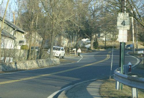 The beginning of Franklin Avenue, here signed as primary route 4. |
||
| 4.43 | Franklin Ave | Unnamed stream {bridge} |
| 4.43 | Entering Franklin Lakes Boro | |
| 4.96 | Franklin Ave | Unnamed stream {bridge} |
| 5.04 | Franklin Ave | |
| 5.09 | Franklin Ave | Susqhehanna Railroad {at-grade crossing} |
| 5.17 | Franklin Ave | [Colonial Rd |
| 5.43 | Franklin Ave | (Pulis Ave |
| 5.43 | Next 0.82 mile co-signed with |
|
| 5.89 | Franklin Ave | Summit Ave [ |
| 5.94 | Franklin Ave | Unnamed stream {pipe} |
| 6.25 | Franklin Ave | [Ewing Ave |
| 6.25 | ||